Description
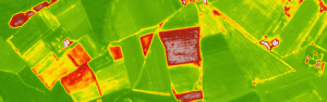
With the help of these indices you can get information about forest massifs: vegetation density, drought-covered areas, forest fire hazard.

Vegetation density, drought areas, forest fire hazard
15,00 €
With the help of these indices you can get information about forest massifs: vegetation density, drought-covered areas, forest fire hazard.
You have not viewed any product yet.
Reviews
There are no reviews yet.